Описание
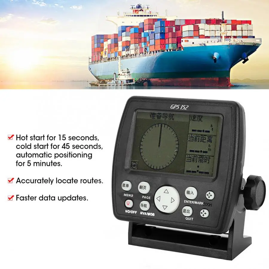
4 inches Marine GPS Satellite Boat Navigator LCD Display Screen
Feature:
1. Waterproof, no water in 3.28ft (1meter) and 30 minutes underwater. Moisture proof, salt-spray resistant.2. Hot start for 15 seconds, cold start for 45 seconds, automatic positioning for 5 minutes.
3. Drag anchor, arrival, yaw, proximity and clock alarm.
4. Accurately locate routes and give you a better experience.
5. Faster data updates, more accurate and secure.
Specification:
Condition: 100% Brand New
Item Type: Satellite Navigator
Color: Shown as Picture
Display: Approx. FSTN1 10.2cm/4 inches LCD Screen
Pixel Dot Matrix: 160 x 100
Size: Approx. 13.4 x 12.5 x 6.1cm/5.28 x 4.9 x 2.4in
Temperature Range: -15 ° C -70 ° C
Shell: Waterproof (under Water for 3.28ft(1Meter) and 30 Minutes), Moisture-proof, Salt-proof
Power Supply Voltage: 10 -40V DC
Power Consumption: 10V Power Supply, Maximum Power Consumption 5W
Channel: 12 Channels
Start: Hot Start for 15 Seconds, Cold Start for 45 Seconds, Automatic Positioning for 5 Minutes
Positioning Accuracy: Approx. 15 Meters/49.2ft
Data Update Rate: 1 Second, Continuous Automatic
Speed Accuracy: 0.05M(0.164ft) / Sec
Acceleration: 6g
Interface: RS-232
Interface Settings: NMEA0183 and DGPS
Waypoint: 500
Route: 20Lines, 30 Points Each Line
Track: 10
Track Point: 2000
Alarm: Drag Anchor, Arrival, Yaw, Proximity and Clock Alarm
Coordinate System: Warp/latitude, UTM/UPS, MGRS, LORAN TDs, Other Coordinate Systems
Item Type: Satellite Navigator
Color: Shown as Picture
Display: Approx. FSTN1 10.2cm/4 inches LCD Screen
Pixel Dot Matrix: 160 x 100
Size: Approx. 13.4 x 12.5 x 6.1cm/5.28 x 4.9 x 2.4in
Temperature Range: -15 ° C -70 ° C
Shell: Waterproof (under Water for 3.28ft(1Meter) and 30 Minutes), Moisture-proof, Salt-proof
Power Supply Voltage: 10 -40V DC
Power Consumption: 10V Power Supply, Maximum Power Consumption 5W
Channel: 12 Channels
Start: Hot Start for 15 Seconds, Cold Start for 45 Seconds, Automatic Positioning for 5 Minutes
Positioning Accuracy: Approx. 15 Meters/49.2ft
Data Update Rate: 1 Second, Continuous Automatic
Speed Accuracy: 0.05M(0.164ft) / Sec
Acceleration: 6g
Interface: RS-232
Interface Settings: NMEA0183 and DGPS
Waypoint: 500
Route: 20Lines, 30 Points Each Line
Track: 10
Track Point: 2000
Alarm: Drag Anchor, Arrival, Yaw, Proximity and Clock Alarm
Coordinate System: Warp/latitude, UTM/UPS, MGRS, LORAN TDs, Other Coordinate Systems
Package List:
1 x Display
1 x Mounting Bracket Kit
1 x Detection Radar
1 x Wiring Harness
1 x Chinese and English Manual





Характеристики
- Бренд
- Zerone
- GPS Навигатор с TF Карты
- Нет
- Разрешение экрана
- 320x240
- Особые характеристики
- FM-передатчик
- feature 1
- Marine GPS
- feature 2
- Navigator GPS
- feature 3
- Satellite Navigator
- feature 4
- Marine Navigator
Сопутствующие товары